
بازآفرینی مجازی ارگ بم (بازشناسی گذشته، بازسازی دانشبنیان آینده) - دانشکده معماری arch
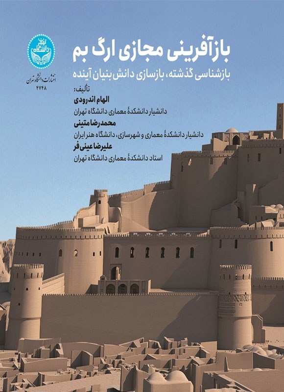
Virtual Reconstruction of Arg-e Bam (Reinterpreting the Past, Knowledge-Based Reconstruction of the Future)
Authors: Elham Andaroudi, Mohammadreza Matini, Alireza Einifar
Publisher: University of Tehran Press
Publisher: University of Tehran Press
Description
The historic Arg-e Bam, located adjacent to the city of Bam, was formed within a distinct natural setting enriched by outstanding man-made features. Numerous qanat systems running from south to north have long conveyed fresh water to the city of Bam—a tradition deeply rooted in the city’s ancient history. Along the Bam fault east of the city, surface evidence of some of the oldest qanats in Iran, dating back to the Achaemenid period, can still be observed. Throughout history, these qanats irrigated the city of Bam and its gardens, sustaining life in the region.
The mud-brick citadel of Arg-e Bam, with construction evidence dating to the Seleucid–Parthian period, has borne witness to the flow of life across different historical eras. With a spatial structure characteristic of the Iranian–Islamic city, Arg-e Bam contains key urban elements such as nested fortification walls, gates, a bazaar, mosque, school, tekyeh, caravanserai, aristocratic residences, and common dwellings. Surrounding the governor’s quarter are military and administrative facilities, including barracks and stables. At the highest point of the governor’s compound stands the Chahar-Fasl Pavilion, a chahartaqi structure, alongside a tall tower and a well carved into the Bam bedrock—elements that point to an ancient and ritual core in this area.
During the Qajar period, following the relocation of residents outside the citadel, Arg-e Bam was abandoned. As a result, it was spared the destruction caused by modern street construction during the early Pahlavi era in the urban fabric of Bam. The tradition of mud-brick construction has continued in Bam to this day, and since the beginning of restoration works in the 1990s, local technologies and craftsmanship based on adobe have been employed in rebuilding efforts.
Following the 1382 (2003) earthquake, cultural heritage advocates, officials, and practitioners in Iran and around the world were confronted—almost unbelievingly and within a short time—with the catastrophic and widespread destruction of Arg-e Bam. Although the citadel had experienced repeated episodes of destruction and reconstruction throughout its history, it had never before suffered devastation on such a scale. The re-creation of Arg-e Bam after the earthquake was a demand of experts and the public alike, and, more importantly, an action toward safeguarding a national heritage. Now, more than two decades after the Bam earthquake, the reconstruction of parts of the site has gradually become possible. However, due to a lack of sufficient evidence and documentation, the authenticity of some reconstructions remains questionable. On the one hand, the urgent need to preserve historical values, and on the other, the complexity of execution combined with structural strengthening requirements, have made the physical reconstruction of the citadel costly, time-consuming, and in some areas impossible.
The objective of rescuing Arg-e Bam in the virtual realm is to recreate the history and events of the citadel while reinterpreting its physical form. Three-dimensional reconstruction with a knowledge-based approach not only contributes to precise documentation of the site, but also—through the production of static and dynamic images—facilitates better understanding and interpretation for both specialists and the general public. To this end, the research project “Virtual Reconstruction of Arg-e Bam” was planned and pursued as a knowledge-based documentation effort using computer-based 3D reconstruction systems. The research process involved the following key steps:
Historical studies and analysis of the physical transformations of Arg-e Bam and its buildings
Morphological and anatomical analysis of the citadel and its structures
Collection and analysis of data for virtual 3D reconstruction
Three-dimensional reconstruction and advanced modeling through the simultaneous use of heterogeneous data
Error evaluation and correction
Three-dimensional wireframe modeling based on aerial photogrammetry (IFCA Project)
Virtual reconstruction and validation
Three-dimensional visualization
Presentation of visualization results in visual formats
This book presents the above-mentioned challenging research endeavor in an analytical framework across three sections. The first section is devoted to recognizing the history and physical structure of Arg-e Bam—before and after the earthquake. The second section analyzes and introduces the knowledge-based reconstruction of Arg-e Bam, drawing on global experiences. The third section presents a computer-based visual representation of Arg-e Bam. These three sections are interdependent and complementary. Although the core of the book lies in the second section and its analysis of the computer-based 3D reconstruction process, the sequence of these sections within a single volume conveys a clear message: virtual reconstruction of a heritage site is impossible without a precise and comprehensive understanding of it.
The mud-brick citadel of Arg-e Bam, with construction evidence dating to the Seleucid–Parthian period, has borne witness to the flow of life across different historical eras. With a spatial structure characteristic of the Iranian–Islamic city, Arg-e Bam contains key urban elements such as nested fortification walls, gates, a bazaar, mosque, school, tekyeh, caravanserai, aristocratic residences, and common dwellings. Surrounding the governor’s quarter are military and administrative facilities, including barracks and stables. At the highest point of the governor’s compound stands the Chahar-Fasl Pavilion, a chahartaqi structure, alongside a tall tower and a well carved into the Bam bedrock—elements that point to an ancient and ritual core in this area.
During the Qajar period, following the relocation of residents outside the citadel, Arg-e Bam was abandoned. As a result, it was spared the destruction caused by modern street construction during the early Pahlavi era in the urban fabric of Bam. The tradition of mud-brick construction has continued in Bam to this day, and since the beginning of restoration works in the 1990s, local technologies and craftsmanship based on adobe have been employed in rebuilding efforts.
Following the 1382 (2003) earthquake, cultural heritage advocates, officials, and practitioners in Iran and around the world were confronted—almost unbelievingly and within a short time—with the catastrophic and widespread destruction of Arg-e Bam. Although the citadel had experienced repeated episodes of destruction and reconstruction throughout its history, it had never before suffered devastation on such a scale. The re-creation of Arg-e Bam after the earthquake was a demand of experts and the public alike, and, more importantly, an action toward safeguarding a national heritage. Now, more than two decades after the Bam earthquake, the reconstruction of parts of the site has gradually become possible. However, due to a lack of sufficient evidence and documentation, the authenticity of some reconstructions remains questionable. On the one hand, the urgent need to preserve historical values, and on the other, the complexity of execution combined with structural strengthening requirements, have made the physical reconstruction of the citadel costly, time-consuming, and in some areas impossible.
The objective of rescuing Arg-e Bam in the virtual realm is to recreate the history and events of the citadel while reinterpreting its physical form. Three-dimensional reconstruction with a knowledge-based approach not only contributes to precise documentation of the site, but also—through the production of static and dynamic images—facilitates better understanding and interpretation for both specialists and the general public. To this end, the research project “Virtual Reconstruction of Arg-e Bam” was planned and pursued as a knowledge-based documentation effort using computer-based 3D reconstruction systems. The research process involved the following key steps:
Historical studies and analysis of the physical transformations of Arg-e Bam and its buildings
Morphological and anatomical analysis of the citadel and its structures
Collection and analysis of data for virtual 3D reconstruction
Three-dimensional reconstruction and advanced modeling through the simultaneous use of heterogeneous data
Error evaluation and correction
Three-dimensional wireframe modeling based on aerial photogrammetry (IFCA Project)
Virtual reconstruction and validation
Three-dimensional visualization
Presentation of visualization results in visual formats
This book presents the above-mentioned challenging research endeavor in an analytical framework across three sections. The first section is devoted to recognizing the history and physical structure of Arg-e Bam—before and after the earthquake. The second section analyzes and introduces the knowledge-based reconstruction of Arg-e Bam, drawing on global experiences. The third section presents a computer-based visual representation of Arg-e Bam. These three sections are interdependent and complementary. Although the core of the book lies in the second section and its analysis of the computer-based 3D reconstruction process, the sequence of these sections within a single volume conveys a clear message: virtual reconstruction of a heritage site is impossible without a precise and comprehensive understanding of it.